
Key Takeaways
- Mobile technology offers the ability to combine immediate access to information and location through augmented reality and geotagging.
- Dickinson College students in a summer study-abroad program partnered with students from Nanzan University and became engaged in the local community, sharing their thoughts and photos on the Dickinson blog.
- GPS cameras helped students document their daily life and group excursions, creating points of interest in Layar, an augmented reality platform, by geotagging locations.
- Having the blog, with embedded images and maps, as the centerpiece of the project worked very well, and the approach will serve as a template for future study-abroad programs.
Mobile technology provides a great benefit for education — the ability to combine immediate access to information with one's location. At Dickinson College we had been considering ways to use geotagging and augmented reality to connect students with the world beyond the classroom. We considered several ideas for local community projects using augmented reality, but decided one of our study abroad programs would benefit the most.
Dickinson College has a strong focus on international study. Most of our students study abroad for a semester or longer, but summer programs that last four to five weeks are also popular. These short programs pose particularly acute cultural challenges for students, many of whom are either completely unfamiliar with the local language before they arrive or have only one or two semesters of language training. We theorized that a project using mobile devices would give our students meaningful opportunities to quickly connect with the local culture and share these experiences as part of an academic assignment.
One of the programs open to the idea was the summer program in Japan, led by Alex Bales and Akiko Meguro. Professors Bates and Meguro had already begun thinking of ways for our students to meet local students and become engaged with the local community. They had settled on a project that would partner Dickinson students with students from Nanzan University in Nagoya. The local students would introduce our students to life in Nagoya and locations around the city. This became an ideal fit for the mobile learning project we had in mind.
Professors Bates and Meguro planned on having their students journal their experiences via the Dickinson blog. In addition to writing on the blog, students were given GPS cameras to document their daily life and group excursions. They were asked to adopt a location and create a point of interest (POI) of the location in Layar, an augmented reality platform. Finally, the students would do a final presentation on the place they had adopted.
The Project in Detail
Before leaving for Japan, students received a description of the project as a whole and a brief introduction to the technologies they would use. The first part of the project involved writing to the course blog as part of their journal assignment and online discussion for the course. For their journal, students were asked to post their impressions and photos about their experiences at least twice a week. The online discussion was designed for students to connect their class work with the group excursions. Three people per day were assigned to post on things they found interesting in either the local sights or the course readings. They could post reflective pieces, questions with some thoughts on the answers, or a close reading of a passage. These posts would form the beginning of a discussion thread to which all of the other students could respond.
Steps in the Project
If staff do not have access to an institutional blogging platform, they can find the same functions at hosted blog sites such as WordPress.com or Blogger. We created the course blog on the Dickinson WordPress multi-site and added accounts for each student. Figure 1 shows a screen capture of a blog post from the summer 2010 program.
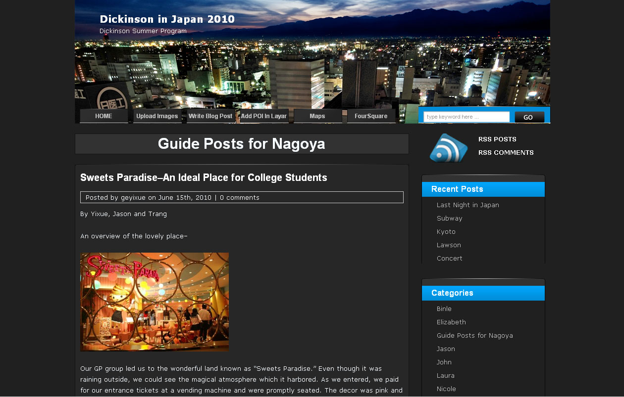
Figure 1. View of the Class Blog
In the second part of the project, students created a digital essay by organizing a collection of 20 to 30 of their favorite images. The images could have a coherent theme or simply showcase their experiences. We showed the students how to use GPS-enabled digital cameras (Figure 2), which we purchased and lent to the students for the duration of the summer program, because the GPS cameras automatically included the longitude and latitude of each photo. We also showed the students how to upload the pictures they took to a Google Picasa web album created for the class, with separate albums for each student to upload their photos. We chose Picasa because it could automatically read the latitude and longitude from the cameras and plot the photos on a map. The images would then automatically appear on a Google Map using the latitude and longitude coordinates recorded by the camera. Students were asked to verify that the location appeared on the map connected with their Picasa web albums, and if not to geotag the images by hand. (We had initially planned on using Flickr with Yahoo maps, but to do so would have required that students manually enter the longitude and latitude of each image.) Figure 3 shows a map from the course, with image locations marked within the city of Nagoya.
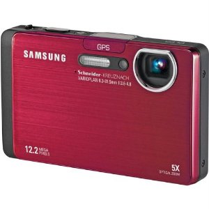
Figure 2. Samsung GPS-Enabled Camera
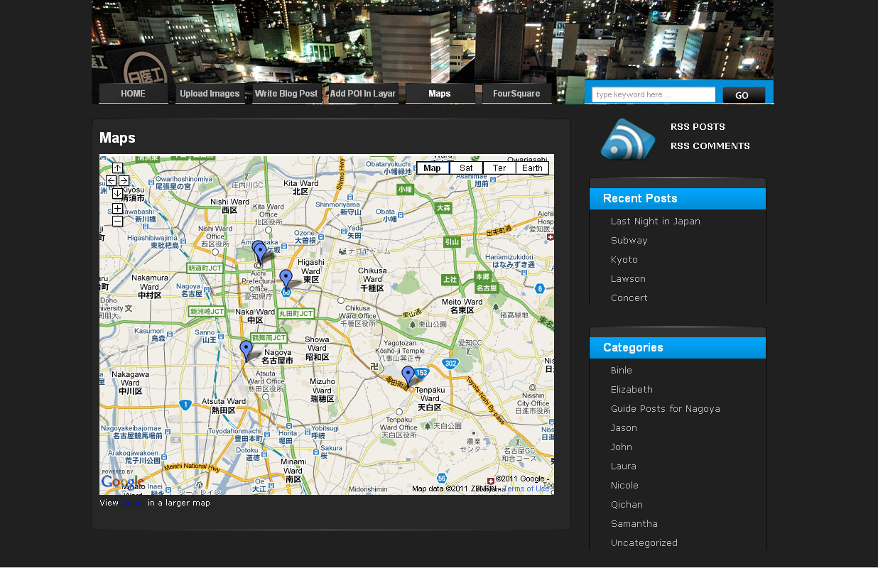
Figure 3. Google Map of Nagoya with Geotagged Locations
For the third part of the project, students created an augmented reality layer that showcased their favorite locations in Japan. Before the course began, students saw a demonstration and read a description of the augmented reality browser, Layar, along with how they would create their own augmented reality layer in Nagoya. Upon arrival in Japan, the students met with local students at Nanzan University and discussed college life in Japan. Their local partners then showed them locations outside the university that they enjoyed and that were popular with students, such as a karaoke bar, club, park, or manga store. Following the discussion, students shared the location with the rest of the class on the program's blog and posted it to the layer.
More About Layar
- Layar is a mobile augmented reality application that displays real-time digital information, called "layers," on top of reality. A layer consists of a series of points that contain geographical data, multimedia, web links, images, and text. Mobile devices that run the Layar app can then find and view these points of interest (POIs) via its integration with the device's camera and GPS functions.
- To allow our students to add data to their own layer in Japan, we had to first create a developer account on Layar.com and then create the "Dickinson in Japan" layer. We created a MySQL database to store the information for each POI, and then two PHP pages, one where students entered their information, which included a title, short description, picture, latitude, longitude, and a link to a blog post about the student and place. The other PHP page linked the information from the database to the Layar application. Once this was done, anyone within a specified range of Nagoya could find a map of our students' POIs. More detailed instructions on how to create a layer is available on their developer's wiki.
- For those hesitant about starting a small course project that requires a MySQL database and coding — albeit simple — in PHP, tools now available for Layar provide a simple web-based user interface for creating your own layer and adding POIs. We have since worked with Hoppala and found that it works well. It is, however, still in beta.
- In addition to Layar, another popular augmented reality browser is Wikitude. Wikitude comes with a simple interface for adding POIs along with the ability to import KML files from Google Earth. Unlike with Layar, however, developers cannot create their own layers if they're using the basic interface. Instead, points are added to the general Wikitude environment, wikitude.me.
See a slideshow for the Layar app here:
For the last part of the project, the students were assigned a traditional final paper along with a presentation.In the paper they explored an idea, location, historical figure, or story they found most interesting during their time in Japan. The papers provided background information but also went beyond the simple Wikipedia entries for the topics. The presentation, for which the students could use PowerPoint, was on the same topic.
Outcomes
Having the blog as a centerpiece, along with the embedded images and map, functioned very well. Students enjoyed reading and writing about their experiences, and it provided a way for everyone, including the students from Nanzan University, to participate in the discussion. We did have some issues with the GPS cameras finding a signal in areas with many high-rise buildings, but students had little difficulty adding their images manually by dragging them onto the map within Picasa Web.
Students were also able to create their POIs with little trouble. However, because their own smartphones either didn't work or would have been prohibitively expensive to use in Japan in locations without Wi-Fi, they usually only read the information from other students via the blog. On the positive side, it worked well as a way to encourage our students to venture out into the city with their counterparts from Nanzan University. Our hope for the future is that students will use the layer to become more immediately acquainted with locations around the city and continue to add to the project.
Overall both the students and professors leading the program were happy with the project. We plan to use it as a template for future study-abroad programs where the technology is viable. We expect that the creation and viewing of augmented reality will become easier each year as more affordable tablets with their accompanying larger screen sizes become more common and less reliant on specific cell carriers. We are focusing in particular on the new Android-powered tablets with cameras and GPS, such as the Samsung Galaxy Tab, and will investigate the new iPad with its front-facing and rear-facing cameras. With this expanding technology we can bring classroom learning out into the field. Currently, Dickinson is helping support The House Divided project in creating an augmented reality layer that will allow users to access and interact with historical information as they tour U.S. Civil War sites.
Resources
Blogging Software
Program's blog: http://blogs.dickinson.edu/japan2010/
Free hosted WordPress: http://wordpress.com
WordPress 3: http://wordpress.org/
Instructions for converting WordPress into a multisite installation: http://codex.wordpress.org/Version_3.0#Multisite
Plug-ins Used
Allows HTML tags that the WYSIWYG editor would normally strip out; used for Google Maps: http://wordpress.org/extend/plugins/unfiltered-mu/
Spam filter: http://akismet.com/
GPS Camera
Samsung CL65: http://bit.ly/fO97yc
Images
Image hosting with Google Maps integration: http://picasaweb.com
Image hosting with Yahoo Maps integration: http://flickr.com
Augmented Reality
Layar: http://layar.com
Hoppala: http://www.hoppala-agency.com/
Wikitude: http://wikitude.com
© 2011 Ryan Burke and Todd Bryant. The text of this EQ article is licensed under the Creative Commons Attribution-Noncommercial 3.0 license.